Tuesday, February 28, 2023

Sipapu Natural Bridge


Friday, October 14, and the day’s park was Natural Bridges National Monument in Lake Powell, Utah. While the park certainly has hiking trails, a lot of it can be seen from the 9 mile loop drive. First up on the one-way drive is Sipapu. Its 268 foot span makes it the largest in the park and the second largest in the world. If you don’t really see it, check the next shot.

Sipapu Up Close

A natural bridge is formed by flowing water whereas an arch is shaped by more generalized erosion such as from wind, rain, ice, etc.
 

Ancestral Puebloan Cliff Dwelling 1

Next up on the progression around the loop was the 0.6 mile / half hour (round trip) / “mostly level” trail to Horse Collar Ruin Overlook. Virginia might dispute that “mostly level” part. 

After having been at the end of the trail for perhaps 10 minutes K+V began to wonder if the effort to walk the trail had been worth it. Virginia spotted the cliff dwellings first. Ken eventually did so too and with his zoom lens not quite maxed out (131 of 250 mm here) Ken got a decent shot.
 

Ancestral Puebloan Cliff Dwelling 2

To the right of the previous shot. Zoom is 220 of 250 mm here so Ken was glad he’d carried the tripod. 

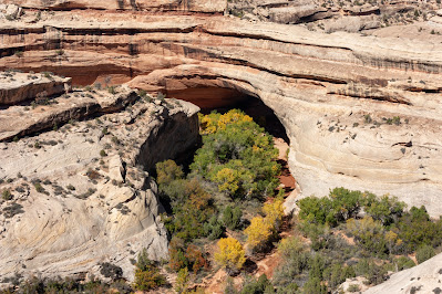
Kachina Bridge

This is the least visible of the bridges from the overlooks since the left side of the span is hidden by cliff. See next shot.
 

Kachina Up Close


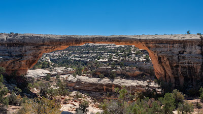
Owachomo Bridge


Quite contrary to what Ken had read in advance the ranger told K+V that if they were going to hike to any of the bridges this should be the one. Unfortunately they arrived as the sun was more or less directly overhead so this picture is not all that great.

Owachomo Bridge from the Other Side


Disappointed at the sun’s angle, and taking the ranger at his word, Ken decided to tackle the trail to get a better shot of the bridge from the other side. The trail description reads: “The trail declines 188 feet to the base of the bridge using wooden and rock stairs. Total trail length (round trip) is 0.5 miles. There is uncertain footing in places. This trail may be difficult for individuals with mobility impairments.” Virginia decided to wait in the car.

The Proof he Made It


Ken thought he was quite tired when he made it to the bottom. Between the midday sun and the elevation, “tired” got a whole new meaning by the time he got back to the top. But he was glad he’d dragged his tripod along, for two reasons. #1 – It enabled this shot. #2 – He used it to catch himself as he was about to tumble down the titled slick rock and into Armstrong Canyon on the south side of the arch. Ken’s only regret from the whole adventure was that he was so tired it never occurred to him to shoot this shot in portrait orientation initially.

Bear’s Ears

With Natural Bridges complete, it was time to head north on Utah SR-95 towards Torrey and Capitol Reef National Park. Since it was only a 3 hour or so drive, there was time to stop and take pictures along the way.  First up were the two prominent buttes in the distance called the Bears Ears. Several Native American tribal groups consider this area sacred and include it in their oral traditions. The Bears Ears can be seen from as far east as Mesa Verde in Colorado and as far south as Monument Valley in Arizona and are important landmarks for travelers in the Four Corners region.
 

Jacob’s Chair


An unexpected find on the east side of UT-95 about 12 miles south of where the highway crosses the Colorado River. It is composed of red sandstone towering to 6,775 feet above sea level and roughly 600 feet above the surrounding terrain. It is not named for the biblical Jacob but rather for Jacob Adams, a cattleman in the area, who lost his life crossing the White Creek in the area of White Canyon.

Colorado River from Hite Overlook


When the Glen Canyon dam was built across the Colorado River, Lake Powell was created, and the town of Hite was submerged.

Drying Lake Powell

Looking to the right from the previous shot (towards the southwest) the extent of the drying up of Lake Powell becomes quite apparent.
 

Hite Ferry Location

In the late 1890s, Arthur Chaffin came to Hite with his father and brothers looking for gold. After little luck they gave up. As other mineral booms occurred in the region, Chaffin took advantage of the largest - the uranium boom. Since Hite was situated at an important Colorado River crossing, he established a ferry. His ferry operated from the 1946 to 1964, when Lake Powell was filled.
 

Feeling Small 1

UT-95 was a nice smooth good road, and surely gets up close and personal with the surrounding features.
 

Feeling Small 2


Ken included the car in the shot to provide some scale, but it’s a good view of it too. The car was a Nissan Maxima. Great gas mileage and easy to drive. It was low though. That meant it hugged the road, but was not easy to get in and out off, and just how low to the ground it was became an issue in later days.

Hogwash Recreation Area

A small picnic area, but with a trail leading to a spring. Shot taken mainly to show the red rocks.
 

A Road Runs Through It


UT-95 was blasted right through the rocks.

Capitol Reef National Park

By about 5:15 V+K were past the tiny village of Hanksville, headed west on UT-24, and within in the boundaries of Capitol Reef National Park. Capitol Reef is different than most of the wilderness parks in the area as it was a place settled and cultivated by Mormon pioneers. While it’s not particularly scenic, of note in this shot is the green water fountain in the right foreground. ALL the parks made a point of providing free water and stressing the need to stay hydrated. Ken supposes doing so was vastly cheaper than needing to rescue hikers that collapsed from dehydration.
 

Behunin Cabin

The cabin shown here was built in 1882 by Elijah Behunin, one of the earliest Mormon settlers to come to this area, to house his family which included 13 children. After seeing just this wee preview of the park the travelers checked in to their hotel and headed to a local pizza place to get dinner. After waiting for 45+ minutes for their pizza to arrive, they left and headed back to eat the mediocre and somewhat pricey dinner at their hotel.
 

Fruita Schoolhouse


The Mormon settlement that later became part of Capitol Reef Park was named Fruita for the groves of apple, peach, pear and apricot trees the Mormons cultivated there at the confluence of Sulphur Creek and the Freemont River. Most of the village was along what is now the main scenic drive, south of the UT-24 highway. But on the north side of the village, along what is now UT-24, they built this one-room schoolhouse.

Second Round of Petroglyphs #1


Immediately adjacent to the schoolhouse to the east were a series of petroglyphs created between approximately 300 and 1,300 AD. They are attributed to the Freemont Culture ancestors of today's Hopi, Zuni, and Paiute tribes.

Sunday, February 26, 2023

Second Round of Petroglyphs #2


Second Round of Petroglyphs #3


Second Round of Petroglyphs #4


Capitol Dome

The feature that gave Capitol Reef Park half of its name. Early white explorers of the area noted how it looked like the dome of the US Capitol building. Taken from the WILDLY popular Hickman Bridge trailhead parking lot.
 

Navajo Stacks


The one in the center is called Navajo Dome. The dome is the result of hard sandstone being sculpted by winds and scoured by water erosion.

Heading into Fruita

This shot was taken from the machine shop parking lot looking across the street towards the Nature Center (which was closed). It shows the first views of the groves, but the real focus is on the majestic setting with the massive canyon walls in the background.
 

Freemont River Flowing Through Fruita

The river was not really that impressive, but apparently severely floods during the Monsoon Season, and provides enough water for the groves.
 

Gifford House

The sole remaining pioneer home in the park. Advertised as a museum, it was closed when Virginia and Ken arrived. After lunch, when it reopened, K+V found it to be more of a store than a museum.
 

Historic Orchards

The Mormon pioneers planted thousands of fruit trees in the Freemont River Valley. From the 1880s to the 1960s these trees provided food and income to the ten or so families that called this area home. Park staff maintain the historic character of these orchards using heritage techniques. The same flood irrigation ditches the pioneers dug water the trees today. In season park visitors are permitted to pick ripe fruit for their personal consumption. No fruit was available during Ken + Virginia's visit.
 

Scenic Drive

Extending out of Fruita to the south is a dead-end 13 mile scenic drive, the first 8 miles of which are paved. That’s Navajo Dome in the background.
 

An Example of “The Reef”

Unlike Capitol Dome, no one specific feature in the park lays claim to the “reef” part of the park’s name. That term refers to the overall look of the rock uplift that is the dominant feature of the park.
 

Classic View

This is Ken’s shot, but you can see this same view in a lot of the material for the park. What amazed Ken the most about this shot is that he did ZERO post-processing on it, not even a crop or exposure adjustment. Ken’s original intent was to remain at this spot and document the sunset. He got all setup with the camera in a fixed position on the tripod. He then set the timer on his phone to tell him when 3 minutes were up and it was time to take another shot. He laid his phone on the trunk of the car. All that effort turned out to only yield shots showing the shadows creeping up the face of the formation in the background, so Ken packed up him camera and tripod and moved on.
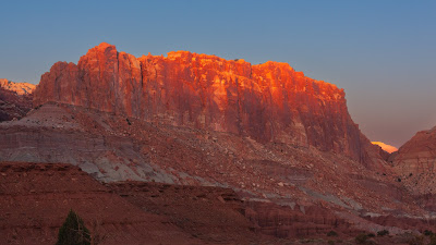
 

Sun Reflecting on the Waterpocket Fold

The Waterpocket Fold is the major geologic feature that defines Capitol Reef National Park. It is a buckle in the earth's surface, almost 100 miles long, running north-south from Thousand Lake Mountain down to Lake Powell. Along The Fold, rocks have been pushed upward and erosion has cut through the layers, creating deep narrow canyons and interesting formations. East-west travel across The Fold is difficult because of the rugged terrain; there are only a few spots where roads have been pushed through. Highway 24 crosses the mid-section of the park and provides access to visitor facilities. It is the only paved road to cross the Waterpocket Fold. The name "Waterpocket Fold" reflects this ongoing erosion of the rock layers. "Waterpockets" are small depressions that form in many of the sandstone layers as they are eroded by water, and are common throughout the fold at Capitol Reef. When Ken stopped to take this shot he remembered he’d never taken his phone off the trunk of the car. AMAZINGLY IT WAS STILL THERE!
 

Thousand Lake Mountain

Sunday, October 16, was planned as a “day off” – time to rest up, hang around the hotel, and relax. After a breakfast at a “foo-foo” restaurant in Torrey, Ken + Virginia made a quick run to the nearby town of Bricknell, to get gas before the open country drive the next morning. Along the way they spotted a semi-scenic view.
 

Nielsen Grist Mill


Capitol Reef Resort

V+K stayed at the hotel closest to the park.
 

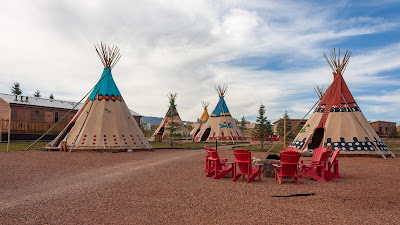
They Had Teepees

 As guest accommodations.
 

Lots of Them


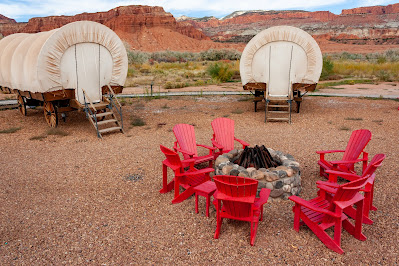
Wagons Too


As Well as Cabins


But alas as of the start of October the tee pees and wagons were not available due to the colder weather.

It Had a Normal Hotel Too

And that is where V+K stayed.
 

With a Decent Pool Area

Ken sampled the hot tub despite the temperatures being in the 60s and the skies being fairly cloudy.
 

Llama Rides

Ken and Virginia didn’t do that either.

Aspens in Full Color

Monday morning came and it was time to head down Utah-12 for Bryce Canyon. This was a slightly longer routing than the fastest route, but since it was marked as a scenic drive on the map Ken decided to try it. A lot of the route was near 9,000 feet above sea level and the Aspens were in full color up at that altitude.
 

Grand Escalante Staircase


After coming down from the mountains Ken and Virginia got a nice view of the Grand Escalante Staircase. The TINY town, just about in the center of the picture, is Escalante. At one time Ken was considering taking their recovery days at a resort there. When he saw the town he was glad he’d changed his mind – for two reasons. #1-That would have meant making the mountain crossing drive at night. #2 – It was quickly apparent that the eating places situation was EVEN MORE dismal there than in Torrey.

On the Trail to Mossy Cave

Even before they got to the main section of Bryce Canyon park, Ken + Virginia saw their first hoodoos while hiking the trail to Mossy Cave.
 

Hoodoos

Like almost everything in these parks the hoodoos are the product of erosion. Specifically, in the case of the hoodoos, mostly ice forming in cracks and chipping off the softer rock formations.
 

Colorful Rocks

The trail followed the path of the Tropic Ditch, an irrigation channel dug in an existing water course by Mormon pioneers. Ken became quite fascinated by reddish/purple coloring in the Water Canyon dry wash bed, and noticed it also appeared on the sides of the dry wash where it was clear, water at times would run.
 

The Big Five Parks of Southern Utah Tour

In the late summer of 2022 Ken and Virginia needed to use the airline tickets they had purchased way back in 2020 but could not use due to t...