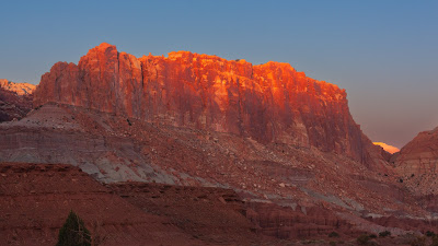
The Waterpocket Fold is the major geologic feature that defines Capitol Reef National Park. It is a buckle in the earth's surface, almost 100 miles long, running north-south from Thousand Lake Mountain down to Lake Powell. Along The Fold, rocks have been pushed upward and erosion has cut through the layers, creating deep narrow canyons and interesting formations. East-west travel across The Fold is difficult because of the rugged terrain; there are only a few spots where roads have been pushed through. Highway 24 crosses the mid-section of the park and provides access to visitor facilities. It is the only paved road to cross the Waterpocket Fold. The name "Waterpocket Fold" reflects this ongoing erosion of the rock layers. "Waterpockets" are small depressions that form in many of the sandstone layers as they are eroded by water, and are common throughout the fold at Capitol Reef. When Ken stopped to take this shot he remembered he’d never taken his phone off the trunk of the car. AMAZINGLY IT WAS STILL THERE!
Subscribe to:
Post Comments (Atom)
The Big Five Parks of Southern Utah Tour
In the late summer of 2022 Ken and Virginia needed to use the airline tickets they had purchased way back in 2020 but could not use due to t...

-
An unexpected find on the east side of UT-95 about 12 miles south of where the highway crosses the Colorado River. It is composed of red s...
-
While K+V were waiting for the sun to appear they decided to see just how tough the “Upper Delicate Arch viewpoint” trail was. It listed in ...
-
Plan B was to drive back to the Canyonlands access road and head into that park. Along the access road were several places to pull out and v...


No comments:
Post a Comment